Aurel Stein’s aerial survey of the Roman Empire’s frontier in Iraq and Jordan, 1938-1939
By Karen Syrett
Download- Date
- 07 Nov 2018
This article is published in British Academy Review No. 34 (Autumn 2018).
The print version of this article can be downloaded as a PDF file.
Karen Syrett has been the British Academy’s Archivist and Librarian since 2012.
The long hot summer of 2018 has been of great benefit to archaeologists, as the extended dry weather revealed evidence of many ancient sites that could then be clearly seen from the air. Eighty years ago, the veteran explorer and Fellow of the British Academy, Sir Aurel Stein, used the technique of aerial archaeology to survey the borders of the Roman Empire in Iraq and Transjordan.
Born in Hungary in 1862, Stein came to England in 1884 to study oriental languages and archaeology, and became a British citizen in 1904. From 1900 to 1930, he conducted major expeditions to Central Asia, and is perhaps best known for his discovery of the Mogao Caves on the Silk Road near Dunhuang. Ever adventurous, Stein had spent years uncovering artefacts from hostile terrain. He was recognised for his contribution to archaeology by election to the Fellowship of the British Academy in 1921. But it wasn’t until 1938, at the ripe age of 75, that he explored ancient sites from the air as well as the ground.
Stein was inspired by the pioneering work already accomplished by the French archaeologist, Antoine Poidebard, who had used aerial surveillance to identify the ancient Roman frontier in what was then French-controlled Syria. The Roman frontier (limes in Latin) demarked the extent of the Roman Empire – a characteristically straight road enabled the efficient transportation of goods and troops, with small forts (castella) at regular intervals to provide security against invasion. Stein determined to continue the work begun by Poidebard by tracing the limes in British-controlled Iraq and Transjordan. Aerial reconnaissance revealed remains that were not always visible at ground level, thus enabling Stein to achieve in weeks what would normally have taken years.
Before the survey could begin, Stein needed to garner the support of various agencies. In 1935, Sir Frederic Kenyon, in his capacity as both Secretary of the British Academy and President of the Society of Antiquaries, provided a statement of support – pointing out how ‘very unfortunate’ it would be if the least adequately mapped part of Rome’s eastern frontier ‘were that for which Great Britain is responsible’ [note 1]. Stein was then able to secure the services of the RAF and the Iraq Petroleum Company.
With his crew and transport assembled and permission granted to work in the area, Stein was finally ready to make his first flight on 8 March 1938. Dressed in a fur-lined flying suit, he took off from Mosul in Pilot Officer Hunt’s Vincent biplane. The Vickers Vincent was ideal for Stein’s purpose: ‘of moderate speed and skilfully piloted, it gave me while standing in the observer’s cockpit just that look forward which search of archaeological objects called for’ [note 2]. On that first outing, Stein was easily able to identify from the air the site of Castellum Najm Jaddala, which Leading Aircraftsman Pascoe then captured on film.
From March to May, Stein continued to survey the area by plane and by car. By 4 April, he was able to report ‘the discovery of 3 Roman castella which settles the previously unsuspected line of the Roman road connecting the well-cultivated centre of the Sinjar range with the great stronghold of Nisibis’ [note 3]. Six weeks later, he had traced the southern extension of the limes, but by now the weather had become intolerably hot, and so the project was put on hold until the crew were able to reassemble in the cooler autumn months.
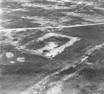
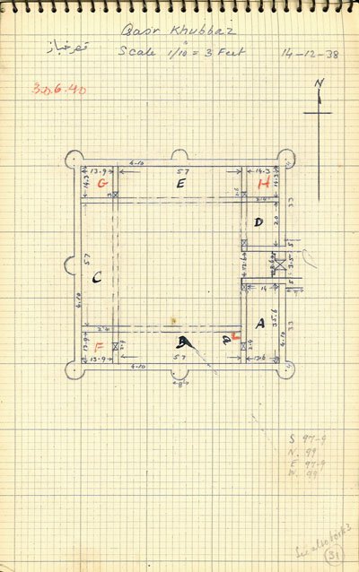
On 12 December 1938, whilst surveying the ancient sites along the Euphrates, Stein was ‘delighted’ to see from the air ‘an unmistakable Roman castellum, the best preserved I had so far seen. It is known as Qașr Khabbāz.’ Over the next three days Stein examined the site on the ground, and drew a plan of the castellum in his notebook. In the ravine beside the fort a barrage had been constructed – ‘showing all the skill of Roman engineering’ – to create ‘a great reservoir’ on a long waterless stretch of the desert highroad. For Stein it was significant that this outpost – solidly built to be ‘completely “tribal proof” to borrow an expression from the Indian North-west Frontier’ – was ‘the southernmost point so far known towards the centre of the Mesopotamian plain and the Persian Gulf where the organizing power of Rome has left its mark on the ground’ [note 4].

On 1 June 1939, The Times reported that Stein had now returned to England having completed the survey of the old Roman boundary begun by Poidebard by including the sections in Iraq and Transjordan. The report revealed that, at Erbil, ‘Sir Aurel Stein visited the site of the battle of Arbela, and was able to satisfy himself as to the correct position of this spot made famous by the campaign of Alexander the Great’ [note 5].
Stein published two articles on his aerial and ground surveys in the Geographical Journal. But when he died in 1943, at the age of 80, the full text of his Limes Report remained unpublished. In 1949 all the materials were in the hands of Kenneth Mason, Professor of Geography at the University of Oxford, and he deposited them with the new Secretary of the British Academy, the archaeologist Mortimer Wheeler FBA. Two Fellows of the British Academy – Sir Ronald Syme and Professor A.H.M. Jones – provided Wheeler with comments on what might be done to prepare the report for publication. But in 1954 the archaeologist David Oates led an expedition to examine and report on the ancient sites observed by Stein; and he concluded that more work needed to be done to test the reliability and accuracy of Stein’s sometimes ‘imaginative’ account, and advised against publishing the typescript in its present form [note 6].
The Limes Report was finally published in 1985, in the British Archaeological Reports, International Series (no. 272). This publication was dedicated to Surveyor Iltifat Husain and Pilot Officer Leslie H. Hunt: since the maps and the photographs and maps were what his survey was all about, the volume editors Shelagh Gregory and David Kennedy felt sure that Stein would have approved of the dedication.
Dr Robert Bewley of EAMENA (Endangered Archaeology in the Middle East and North Africa) explains the continuing significance of Stein’s achievement. ‘Sir Aurel Stein was an indomitable pioneer: building on the work of previous scholars, he paved the way for future researchers. His legacy lives on in that the Aerial Archaeology in Jordan (AAJ) project, established by Professor David Kennedy in 1997, can trace its roots back to Stein. The similarities of working with the relevant air forces continue – Stein with the RAF, and the AAJ with the Royal Jordanian Air Force (RJAF). The AAJ project has had a close relationship with the British Academy, which awarded grants to help set it up in the late 1990s and early 2000s [note 7]. The annual aerial reconnaissance expeditions continue, as well as adding other photographic material to the Aerial Photographic Archive for the Middle East (APAAME).’
The Stein aerial photographs held by the British Academy have been digitised and georeferenced, and can be consulted online via APAAME, thanks to Rebecca Repper. She adds: ‘The significance of Stein’s work is not only in the discovery of archaeological sites, but also the records and collections he left behind. Archaeological methodology and understanding have evolved drastically since Stein’s fieldwork, but his written account and prolific photographic and topographical records still provide priceless insights into an archaeologically and culturally rich and diverse landscape. Stein’s archive is fundamental to our investigation of the modern landscape, in that we can analyse the historical appearance or locations of sites, monitor the changes, and aim to prevent future destruction of sites that he recorded. The upheaval experienced in this region makes Stein’s evidence an even more precious contribution to the archaeological record.’
Notes
1. Statement on ‘Survey of Eastern Frontier of the Roman Empire’, November 1935 (BAA/SEC/2/6/3).
2. Jeannette Mirsky, Sir Aurel Stein: Archaeological Explorer (1977), p. 517.
3. Ibid, p. 512.
4. Typescript of Aurel Stein’s Limes Report (ASA/2/11).
5. Helen Wang, Sir Aurel Stein in The Times (2002), p. 127.
6. ‘Summary Report on an Expedition to Northern Iraq under the auspices of the British Academy’, November 1954 (ASA/2/13). David Oates was himself elected a Fellow of the British Academy in 1974.
7. Robert Bewley and David Kennedy, ‘Aerial archaeology in Jordan’, British Academy Review, [5] January-July 2001, 55-57.
Header image is aerial photograph of Erbil – what is now the capital of Iraqi Kurdistan – taken on 14 November 1938 (ASA/3/248).